
I. IN BRIEF
I.1. Flight Preparation
Before each flight, you must check the METAR and TAF for your departure airport, destination airport, alternate airport, and even en-route alternates.
METAR
TAF
I.2. Code
A METAR is valid at the time of observation and generally considered reliable for 30 to 60 minutes until the next report is issued. When included, the TREND forecast is valid for up to 2 hours.
I.2.1 Example of METAR decoding
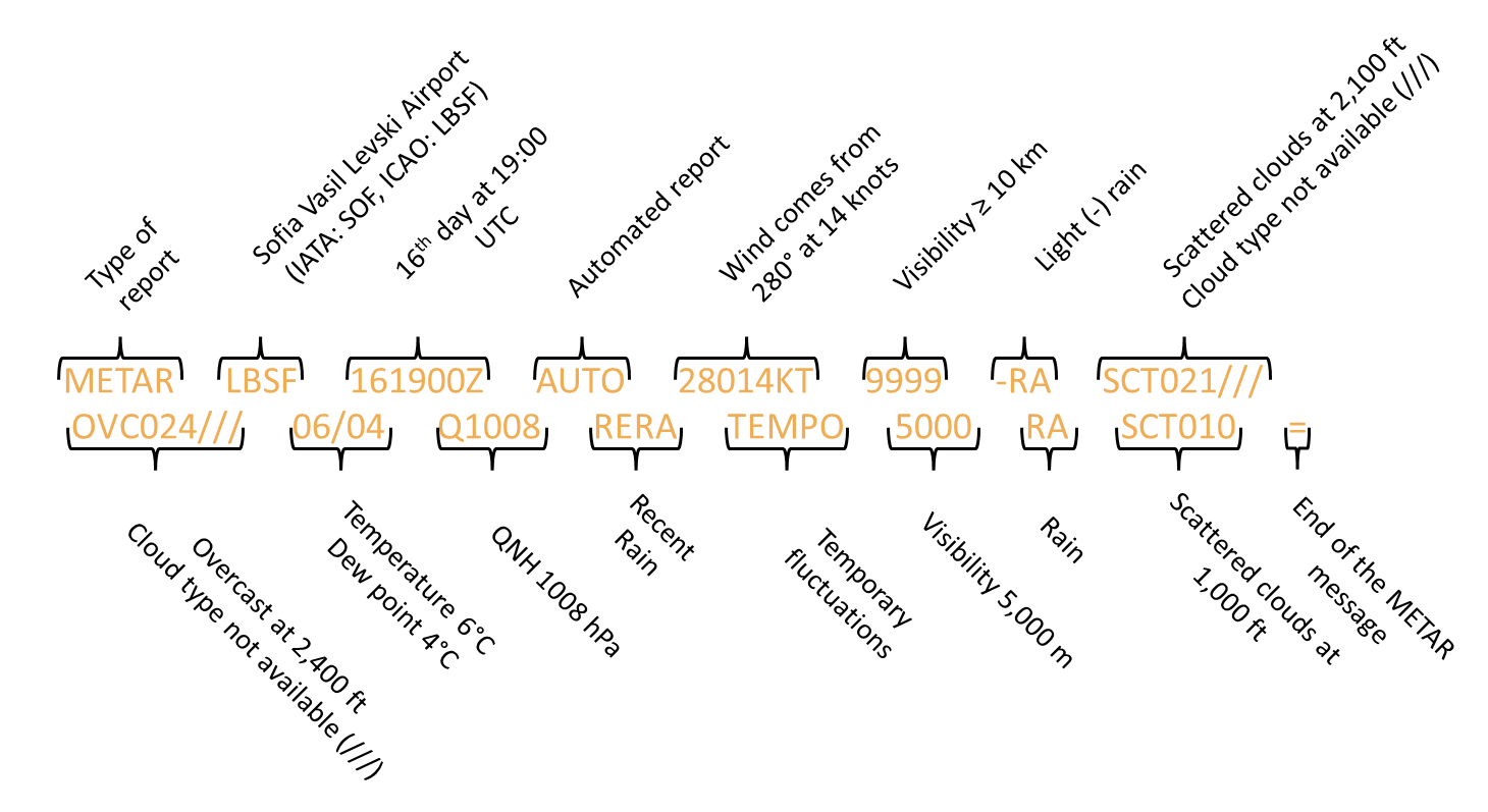
In METAR and SPECI, surface wind direction is reported in degrees true.
In ATIS, surface wind direction is reported in degrees magnetic.
I.2.2 Surface wind direction and speed
VRB
Variable
windG25KT
Gusting
to 25ktCALM
Calm
(wind speed of less than 1 kt)P99KT
100 KT or more
I.2.3 Visibility
N, NE, E, SE, S, SW,W,NW
Sectors can be used to indicate lower visibility than prevailling visibility
EXAMPLE
6000 0600S
Prevailing visibility is 6,000 m, reduced to 600 m in the south sector.
I.2.4 RVR
P
M
U
D
N
I.2.5 Weather Phenomena
No sign Moderate
Heavy
VC Vicinity
BL Blowing
DR Low Drifting
MI Shallow
BC Patches
PR Partial
TS Thunderstorm
FZ Freezing
RA Rain
SN Snow
SG Snow Grains
PL Ice pellets
GR Hail
GS Small hail and/or snow pellets
UP Unintentified precipitation
BR Mist
HZ Haze
SA Sand
DU Dust
FU Smoke
VA Volcanic ash
SQ Squall
FC Funnel cloud
DS Dust storm
SS Sandstorm
VC = Vicinity: Means within approximately 8 to 16 kilometers of the aerodrome reference point (ARP).
//
RE
I.2.6 Clouds
NSC
NCD
FEW
SCT
BKN
OVC
CAVOK
- Visibility ≥ 10 km (lowest visibility not reported)
- No clouds of operational significance
- No significant weather
VV
Reported when sky is obscured and clouds cannot be observed of forecasted, followed by value in feet
///
CB/TCU whith ///
VV ///
Used when the sky is obscured but the vertical visibility value cannot be determined due to a temporary system or sensor failure
I.2.7 Significant Meteorological Conditions
CB
TS
MOD TURB / SEV TURB
WS
GR
SEV SQL
MOD ICE / SEV ICE
FZDZ / FZRA
SEV MTW
DS / SS
BLSN
FC
I.2.8 Temperature
M
Indicates negative temperatures
TX
Temperature forecast
TN
Temperature forecast
I.2.9 Significant Change Indicators
NSW
NOSIG
BECMG
TEMPO
lasting less than 1 hour per instance and less than half the total period
PROB30 / PROB40
of alternative meteorological conditions
PROB30 TEMPO / PROB40 TEMPO
FM
TL
AT
I.3. Other Aviation Reports
ATIS
D-ATIS
SPECI
I.4. Common SIGMET Abbreviations
I.4.1 Thunderstorms
OBSC
Obscured
Thunderstorms hidden by haze, smoke, or darkness
EMBD
Embedded
Thunderstorms within cloud layers, hard to see
ISOL
Isolated
Thunderstorms covering less than 50% of the area
OCNL
Occasional
Thunderstorms covering 50% to 75% of the aera
FRQ
Frequent
Thunderstorms covering more than 75% of the aera with little space between
SQL
Squall Line
Thunderstorms forming a line with a little space between clouds
GR
Hail
associated with thunderstorms
I.4.2 Others
CAT
MTW
II. What is a METAR?
A METAR is a coded report providing an actual observation of current weather conditions at an aerodrome. It is primarily used for real-time decision-making for takeoff, approach, and landing.
II.1. Issuance and Validity
- Every 30 or 60 minutes (depending on the aerodrome and regulations);
- Valid at the time of observation; typically considered operationally valid for 30 to 60 minutes. TREND forecasts, when included, are valid for 2 hours.
II.2. Contents of a METAR
METAR shall contain the following elements in the order indicated:
- Identification of the type of report;
- Location indicator;
- Time of the observation;
- Identification of an automated or missing report, when applicable;
- Surface wind direction and speed;
- Visibility;
- Runway visual range, when the reporting criteria are met;
- Present weather;
- Cloud amount, cloud type only for cumulonimbus and towering cumulus clouds and height of cloud base or, where measured, vertical visibility;
- Air temperature and dew-point temperature;
- Atmospheric pressure (QNH and, when applicable, in local routine and local special report, QFE);
- Supplementary information, when applicable.
Exemple of a METAR decoding :
METAR LBSF 161900Z AUTO 28014KT 9999 -RA SCT021/// OVC024/// 06/04Q1008 RERA TEMPO 5000 RA SCT010 =
II.2.1 Location indicator
For aerodromes, location indicators are four-letter codes listed in ‘ICAO Doc 7910 - Location Indicators’.
II.2.2 Time of the observation
Indicates the day and time of the observation in Coordinated Universal Time (UTC), using the format DDTTTTZ, where:
- DD = day of the month;
- TTTT = time in hours and minutes (HHMM);
- Z = indicates UTC (Zulu time).
II.2.3 Identification of an automated or missing report, when applicable
AUTO or NIL
II.2.4 Surface wind direction and speed
The wind is reported in steps of 10 degrees true and 1 kt.
Variations from the mean wind direction during the past 10 min are reported as follows, if the total variation is ≥ 60°:
VRB = Variable wind.
Variations from the mean wind speed (gusts), during the past 10 minutes shall be reported when the maximum wind speed exceeds the mean speed by 5 KT or 10 KT:
G25KT = gusting to 25 knots. Variations from the mean wind speed, during the past 10 minutes shall be reported when the maximum wind speed exceeds the mean speed by 5 or 10 knots.
Gusts must be taken into account—not only for aircraft limitations (crosswind, tailwind, headwind), but also when increasing approach speed. Each manufacturer provides specific procedures in the aircraft flight manual. It is important to know the personal limits you set based on your own experience, such as landing in crosswinds with a taildragger or tricycle gear aircraft, or landing in strong gusty conditions. Refer to our lesson on landing in gusty winds for more details
CALM = Calm = When a wind speed of less than 1 kt is reported, it shall be indicated as calm.
P99KT = When a wind speed of 100 KT or more is reported (e.g., 140P99KT).
Surface wind is measured at 30 ft AGL. Sensors should reflect conditions near runways and touchdown zones. If wind varies along the runway (due to terrain or weather), extra sensors should be installed.
Try a wind component Calculator.
II.2.5 Visibility
Visibility = Visibility for aeronautical purposes, which is the greater of the greatest distance at which a black object of suitable dimensions, situated near the ground, can be seen and recognised when observed against a bright background or; the greatest distance at which lights in the vicinity of 1000 candelas can be seen and identified against an unlit background.
The visibility shall be reported in steps of:
- 50 m when the visibility is less than 800 m;
- 100 m when it is 800 m or more, but less than 5 km, and;
- in kilometre steps when the visibility is 5 km or more, but less than 10 km;
- and it shall be given as 10 km (or 9999) when the visibility is 10 km or more, except when the conditions for the use of CAVOK apply.
In METAR visibility should be reported as prevailing visibility.
Prevailing visibility = the greatest visibility value, observed in accordance with the definition of ‘visibility’, which is reached within at least half the horizon circle or within at least half of the surface of the aerodrome. These areas could comprise contiguous or non-contiguous sectors.
When the visibility is not the same in different directions the lowest visibility observed should also be reported when the lowest visibility:
- < 1,500 m;
- < 5,000 m and < 50% of the prevailing visibility.
When possible, its general direction relative to the aerodrome reference point should be indicated using one of the eight points of the compass
EXAMPLE
6000 0600S
Prevailing visibility is 6,000 m, reduced to 600 m in the south sector
II.2.6 RVR
RVR = Runway Visual Range means the range over which the pilot of an aircraft on the centre line of a runway can see the runway surface markings or the lights delineating the runway or identifying its centre line. In METAR, the RVR shall be reported throughout periods when either the visibility or the runway visual range is less than 1 500 m.
The RVR shall be reported in steps of:
- 25 m when it is less than 400 m;
- 50 m when it is between 400 and 800 m;
- 100 m when it is more than 800 m.
When the RVR is above or below the measurement limits of the system in use, it is reported with a prefix indicating the exceedance.
P = Plus = Greater than. Used when the RVR is above the maximum value that can be determined by the system in use. It is followed by the maximum value that can be determined by the system.
M = Minus = Less than. Used when the RVR is below the minimum value that can be determined by the system in use. It is followed by the minimum value that can be determined by the system.
ABV = Above and BLW = Below are used in local routine reports and local special reports.
When the variation of the RVR values shows an upward or downward tendency, this should be indicated by the abbreviation ‘U’ or ‘D’, respectively. In cases when actual fluctuations during the 10-minute period show no distinct tendency, this should be indicated using the abbreviation ‘N’.
- U = Upward trend (RVR is increasing)
- D = Downward trend (RVR is decreasing)
- N = No distinct tendency (fluctuations without clear trend)
METAR ENGM 221450Z 19005KT 0350 R19R/0400N R01R/0400N R19L/0650U R01L/0400N -RA FG VV002 03/02 Q1010 NOSIG=
EXAMPLE
II.3. METAR Weather Phenomena Decoding Guide
Present weather shall be reported using up to three abbreviations, combining (see the table in the following section):
- Intensity or proximity (e.g., +, -, VC)
- Characteristic (e.g., TS, SH)
- Type (e.g., RA, SN)
EXAMPLE
+TSRA = Heavy ThunderStorm with Rain
If thunder is heard or lightning is detected within the aerodrome during the 10 minutes prior to observation, but NO precipitation is observed, report TS without any qualification.
No sign Moderate
Heavy
VC Vicinity
BL Blowing
DR Low drifting
MI Shallow
BC Patches
PR Partial
TS Thunderstorm
FZ Freezing
RA Rain
SN Snow
SG Snow grains
PL Ice Pellets
GR Hail
GS Small hail and/or snow pellets
UP Unidentified precipitation
BR Mist
HZ Haze
SA Sand
DU Dust
FU Smoke
VA Volcanic ash
SQ Squall
FC Funnel cloud
DS Dust storm
SS Sandstorm
II.3.1 Intensity or proximity
In Local Routine Reports, the following abbreviations may be used to indicate intensity or severity of weather phenomena:
- FBL = Light (feeble)
- MOD = Moderate
- HVY = Heavy
‘MOD’ can be used in an D-ATIS message:
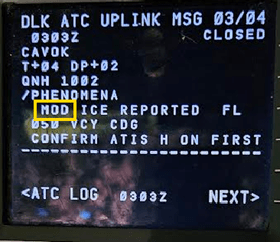
VCY = VC = Vicinity . Means between approximately 8 and 16 km of the aerodrome reference point.
EXAMPLE
METAR EDDL 072120Z AUTO 1700KT 9999 VCSH SCT033 FEW///TCU 14/12 Q1008 RESHRA TEMPO SHRA=
II.3.2 Descriptor - characteristics of present weather phenomena
SH = Shower. Used to report showers.
Showers observed in the vicinity of the aerodrome should be reported as ‘VCSH’ without qualification regarding type or intensity of precipitation.
BL = Blowing. Used to report weather phenomena raised by the wind to 6 ft (2 m) or more above ground level.
DR = Low drifting. Used to report weather phenomena lifted by the wind to less than 6 ft (2 m) above ground level.
MI = Shallow. Used to report a very low layer of fog or other phenomena, less than 6 ft (2 m) above ground.
BC = Patches. Used to report fog patches randomly covering parts of the aerodrome.
PR = Partial. Used to report fog covering a substantial part of the aerodrome while the rest remains clear.
TS = Thunderstorm. Used to report a thunderstorm in progress.
FZ = Freezing. Used to report supercooled water droplets or precipitation, typically combined with other phenomena (e.g. FZRA).
EXAMPLE
METAR EETN 222320Z 18014KT 1000 R26/P2000N +SN BLSN OVC005 00/M00 Q0994=
METAR EETN 131950Z 15017G27KT 1700 SN DRSN BKN008 OVC013 M01/M02 Q0985 TEMPO 15020G30KT 1000 +SN=
II.3.3 Precipitation
DZ = Drizzle. Used to report drizzle.
RA = Rain. Used to report rain.
SN = Snow. Used to report snow.
SG = Snow grains. Used to report snow grains.
PL = Ice pellets. Used to report ice pellets.
GR = Hail. Used to report hail when the largest hailstones are 5 mm or more in diameter.
GS = Small hail or Snow pellets. Used to report small hail or snow pellets when the largest hailstones are less than 5 mm.
UP = Unidentified Precipitation. Used when the type of precipitation cannot be determined (typically in automated reports).
EXAMPLE
METAR LFPG 170230Z 10006KT 8000 -FZRA BKN027 M01/M02 Q0997 NOSIG=
II.3.4 Obscuration
Hydrometeors = water-based particles suspended in the atmosphere, either liquid or solid, that affect visibility or fall as precipitation.
FG = Fog. Used to report fog when visibility is less than 1,000 meters.
BR = Mist. Used to report mist when visibility is between 1,000 and 5,000 meters.
Lithometeors = dry particles such as dust, sand, smoke, or haze suspended in the air that reduce visibility. They consist of non-water-based particles.
The following should be used only when the obscuration consists predominantly of lithometeors and the visibility is 5,000 m or less, except ‘SA’ when qualified by ‘DR’ and volcanic ash:
HZ = Haze. Used to report haze when visibility is 5,000 meters or less, mainly caused by dry particles (lithometeors).
SA = Sand. Used to report sand in suspension in the atmosphere.
DU = Dust. Used to report widespread dust in the air.
FU = Smoke. Used to report smoke affecting visibility.
VA = Volcanic ash. Used to report volcanic ash in the atmosphere.
EXAMPLE
METAR LFPL 110600Z AUTO VRB02KT 9000 NSC 17/10 Q1019 TEMPO 4500 HZ=
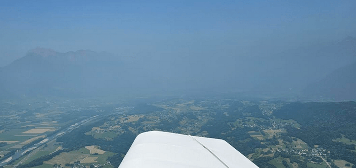
// = Temporary failure of system/sensor. The present weather should be replaced by ‘//’ when it cannot be observed due to a temporary failure of the system/sensor.
II.3.5 Other Phenomena
PO = Dust/Sand Whirls. Used to report small, short-lived rotating columns of dust or sand (dust devils).
SQ = Squall. Used to report a sudden, strong, and brief increase in wind speed lasting at least one minute.
FC = Funnel Cloud. Used to report a tornado or waterspout (funnel-shaped cloud extending toward the ground or water).
DS = Dust Storm. Used to report a widespread dust storm that significantly reduces visibility.
SS = Sandstorm. Used to report a widespread sandstorm causing reduced visibility and surface conditions.
II.3.6 Recent Weather Phenomena
RE = Recent Weather Phenomena. Refers to weather phenomena observed at the aerodrome during the period since the last routine report or within the last hour, whichever is shorter, but not at the exact time of the current observation.
EXAMPLE
RESN, RETSRA, RESHRA
II.3.7 Cloud Type
In a METAR, cloud type is reported only for cumulonimbus (CB) and towering cumulus (TCU) clouds. Other cloud types can be found on SIGWX charts.
II.3.8 Cloud Amount
The cloud amount should be reported using the abbreviations ‘FEW’, ‘SCT’, ‘BKN’ or ‘OVC’.
Oktas are a unit used to describe cloud cover, representing how much of the sky is covered in eighths (1 okta = 1/8 of the sky).
NSC
NCD
FEW
SCT
BKN
OVC
NSC is used when there are no clouds of operational significance and no vertical visibility restriction, but ‘CAVOK’ is not applicable.
NCD = No Clouds Detected. Used when no clouds are detected by an automated observing system.
EXAMPLE
METAR ESCF 072120Z AUTO 20002KT 9999 NCD 08/06 Q1004=
II.3.9 CAVOK
CAVOK = Ceiling And Visibility OK. Used in place of visibility, RVR, present weather, and cloud information when all of the following conditions are met:
- Visibility is 10 km or more (and the lowest visibility is not reported);
- no clouds of operational significance;
- no significant weather is observed.
‘Cloud of operational significance’ means a cloud with the height of cloud base below 5,000 ft or below the highest minimum sector altitude, whichever is greater, or a cumulonimbus cloud (CB) or a towering cumulus cloud (TCU) at any height.
Note: ‘ceiling’ means the height above the ground or water of the base of the lowest layer of cloud below 20,000 ft covering more than half of the sky (BKN, OVC or VV).
II.3.10 Height of Cloud Base
In a METAR, the height of the cloud base is reported, or, when measured, vertical visibility is provided instead.
VV = Vertical Visibility. Used when the sky is obscured and clouds cannot be observed or forecasted. If vertical visibility is available, it is reported using ‘VV’ followed by the measured value in feet.
II.3.11 Unavailable or Unobservable Data (///)
/// = Unknown cloud type. Used when the cloud type cannot be observed; replaces the cloud type in each cloud group.
EXAMPLE
The cloud type cannot be observed, but clouds are detected at various levels:
METAR LFBI 072130Z AUTO 22008KT 9999 FEW010/// SCT020/// BKN035/// 14/14 Q1017 TEMPO BKN009=
CB/TCU with /// = Unknown amount or height. Used when cumulonimbus (CB) or towering cumulus (TCU) clouds are detected, but their amount and/or the height of cloud base cannot be observed. The missing information is replaced by ‘///’.
EXAMPLE
Cloud amount and/or cloud base height unknown (replaced by ///):
METAR EDDW 072120Z AUTO 17003KT 9999 VCSH FEW024 SCT033 FEW///TCU 12/11 Q1007=
METAR LFPM 072130Z AUTO 25016KT 8000 -RA FEW014/// SCT027///BKN040/// ///TCU 14/13 Q1012=
VV/// = Vertical visibility unknown. Used when the sky is obscured but the vertical visibility value cannot be determined due to a temporary system or sensor failure.
EXAMPLE
METAR LFPG 10430Z 12004KT 080V150 0000 R27L/0650D R09R/0750D R26R/1000U R08L/0900U R26/1100U R09R/1000N R27R/0450N R09L/0700D FG VV/// 09/09 Q1025 TEMPO 0300 FG
You're not dreaming, it's a real-world METAR
EXAMPLE
METAR ETNH 072120Z AUTO VRB03KT 9999 // ////// 12/10 Q1005 ///=
In such cases, it’s worth deepening your weather analysis: check charts, satellite imagery, webcams, and other sources to get a clearer picture.
II.3.12 Significant meteorological conditions

‘Significant meteorological conditions’ means any of the following conditions are present:
CB
TS
MOD/ SEV TURB
WS
GR
SEV SQL
MOD ICE / SEV ICE
FZDZ / FZRA
SEV MTW
DS / SS
BLSN
FC
II.3.13 Air temperature and dew-point temperature
M = Minus. Used in METARs to indicate negative temperatures or values below zero. It precedes the numeric value.
EXAMPLE
02/M08 means an air temperature of 2°C and a dew point of –8°C.
Remember, the DP (dew point) is the temperature at which air becomes saturated with water vapor, causing the vapor to condense into liquid water. At this temperature, the air can no longer hold all of the water vapor it contains, and some of it condenses into dew, fog, or clouds. The dew point is a critical measure in meteorology as it indicates the moisture content of the air; a higher dew point means more moisture, while a lower dew point indicates drier air.
The spread, or the difference between the Outside Air Temperature (OAT) and the dew point, is closely related to cloud base height. A smaller spread indicates higher humidity levels and suggests that the air is closer to saturation. This condition often leads to cloud formation at lower altitudes, resulting in a lower cloud base height. Conversely, a larger spread indicates drier air and typically results in higher cloud base heights.
EXAMPLE
METAR LFPG 10430Z 12004KT 080V150 0000 R27L/0650D R09R/0750D R26R/1000U R08L/0900U R26/1100U R09R/1000N R27R/0450N R09L/0700D FG VV/// 09/09 Q1025 TEMPO 0300 FG
Even if the TAF forecast predicts minimum CAT I conditions (which means visibility and ceiling should be good enough for a certain category of instrument landing), actual conditions can worsen unexpectedly. This is especially common in northern countries near bodies of water, where high humidity often leads to rapid formation of fog or low clouds. So pilots should be cautious and prepared for possible reductions in visibility or ceiling despite optimistic forecasts.

II.3.14 Atmospheric pressure (QNH and, when applicable, in local routine and local special report, QFE)
The QNH and QFE shall be computed in tenths of hectopascals and reported therein in steps of whole hectopascals, using four digits.
QFE = Altimeter Pressure Setting to Airfield Elevation. The atmospheric pressure at the airfield reference level, used to set the altimeter to zero at the airfield elevation, indicating height above ground level.
In Europe, we use the unit hectopascals (hPa) to report atmospheric pressure. However, in some other regions of the world—such as the United States—pressure is reported in inches of mercury (inHg).
EXAMPLE
METAR from JFK Airport (KJFK):
KJFK 041151Z 20004KT 10SM FEW250 BKN300 17/15 A3022 RMK AO2 SLP234 FU BKN300 T01720150 51008 $
In this report, A3022 indicates a sea level pressure of 30.22 inHg, which is approximately 1023 hPa.
See our conversion tables in the guide: Math for Pilots for more useful equivalents.
Also, remember to review our course on altimetry—covering topics such as QNH settings, transition altitudes, and flight levels
II.3.15 Forecasts for landing (BECMG, TEMPO, NOSIG)
Although a METAR is an observation report, it may include a forecasts for landing, known as a TREND forecast.
This TREND must begin with one of the change indicators: ‘BECMG’ (becoming) or ‘TEMPO’ (temporary). When no change is expected to occur, this shall be indicated by the term ‘NOSIG’ (no significant change). To indicate the end of a weather phenomenon’s occurrence, the abbreviation ‘NSW’ (nil significant weather) shall be used. See our chapter on significant changes for more definitions.
The validity period of a TREND forecast is 2 hours from the time of the METAR or SPECI it accompanies. While TAFs also use BECMG and TEMPO, the associated changes may extend beyond 2 hours, provided they remain within the overall validity period of the TAF.
As all the aerodromes do not need to be provided with forecasts for landing, the competent authority determines on which aerodromes these types of forecasts will be provided by the aerodrome meteorological office.
The use of ‘PROB’ (probability) is not permitted in TREND forecasts — therefore, it must not appear in a METAR
III. What is a TAF?
III.1. Issuance and Validity
A TAF is a coded forecast describing the expected weather conditions at an aerodrome over a specified period (9 hours, but typically 24 or 30 hours). It is essential for flight planning, alternate selection, and dispatch. See our topic on aerodrome selection policy.
* or 3 hours if so agreed between the competent authority and the meteorological services provider.
At aerodromes with limited hours of operation, the beginning of the period of validity of a TAF should commence at least 1 hour prior to the aerodrome resuming operations, or more as agreed between the aerodrome meteorological office and the operators concerned, to meet planning requirements for flights that arrive at the aerodromes as soon as it is opened for use.
III.2. Contents of a TAF
Generally, the same elements as in a METAR are found, but the TAF is usually longer as it covers a greater forecast period. Significant changes sometimes include probabilities, which are not found in observation messages.
Only some important differences with the METAR section are covered in this chapter.
III.2.1 Temperature range
TAFs may provide the expected highest (TX) and lowest (TN) temperatures during the forecast period, which are important for flight planning and decision-making. In contrast, METARs only report the current temperature at the time of observation.
TX = Maximum Temperature. Indicates the highest air temperature expected during the forecast period, along with the time (UTC) when it is expected to occur.
TN = Minimum Temperature. Indicates the lowest air temperature expected during the forecast period, along with the time (UTC) when it is expected to occur.
EXAMPLE
TAF LEAB 081700Z 0818/0918 14010KT CAVOK TX34/0916Z TN19/0906Z PROB40 TEMPO
0818/0822 16015G25KT FEW035CB PROB40 TEMPO 0902/0908 BKN010=
III.2.2 Atmospheric pressure
Generally, the same elements as in a METAR are found, but the TAF is usually longer as it covers a greater forecast period. Significant changes sometimes include probabilities, which are not found in observation messages.
Only some important differences with the METAR section are covered in this chapter.
IV. Significant Change Indicators: BECMG, TEMPO, PROB, NOSIG, NSW
IV.1. Forecast
Although a METAR is primarily an observation, it may include a short-term landing forecast (TREND forecast), depending on the aerodrome — the provision of such forecasts is determined by the competent authority.
Significant changes affecting one or more of the following elements are indicated:
- Surface wind;
- Visibility;
- Weather phenomena;
In the case of a significant change in visibility, the phenomenon causing the reduction of visibility shall also be indicated.
EXAMPLE
METAR LFBI 051430Z AUTO 21016KT 9999 -RA BKN007/// OVC012/// 16/15 Q1013 TEMPO 3500 RA BKN008 BKN012 SCT015TCU BECMG 21017G27KT=
The total number of phenomena reported in the trend shall not exceed three.
NSW = Nil Significant Weather. Used to indicate the expected end of a weather phenomenon in a TREND or TAF forecast.
EXAMPLE
TAF LBSF 161700Z 1618/1718 29012KT 5000 RA BKN015 OVC040 TEMPO 1618/1621 3000 RA SCT005 BKN015 OVC030 BECMG 1623/1701 9999 NSW SCT030 BKN060=
BECMG 1623/1701 indicates a gradual improvement between 23:00 UTC on the 16th and 01:00 UTC on the 17th, with visibility increasing to 10 km or more, cessation of significant weather (NSW), and an increase in cloud base
NOSIG = No Significant Change. Used when no significant changes are expected during the TREND validity period (within the next 2 hours).
NOSIG is a term used in TREND forecasts only, so you should not find it in a TAF.
EXAMPLE
METAR LFJL 081830Z AUTO 28006KT CAVOK 15/07 Q1022 NOSIG=
Weather conditions are stable, with no significant changes expected over the next two hours.
BECMG = Becoming. Used to describe forecast changes where the meteorological conditions are expected to reach or pass through specified values at a regular or irregular rate. The time period shall not exceed 4 hours.
EXAMPLE
METAR LFBI 051430Z AUTO 21016KT 9999 -RA BKN007/// OVC012/// 16/15 Q1013 TEMPO 3500 RA BKN008 BKN012 SCT015TCU BECMG 21017G27KT=
Within the next two hours, wind is expected to increase, becoming 210° at 17 kt with gusts up to 27 kt.
TEMPO = Temporary. Used to describe forecast temporary fluctuations in the meteorological conditions which reach or pass specified values and last for a period of less than 1 hour in each instance and, in the aggregate, cover less than one half of the period during which the fluctuations are forecast to occur.
EXAMPLE
METAR EETN 050950Z 20009KT 170V240 9999 SCT016 BKN041 18/13 Q1006 TEMPO BKN014=
Within the next two hours, temporary fluctuations in ceiling are expected, with broken clouds at 1400 ft. Each occurrence is expected to last less than one hour and may alternate with higher cloud bases.
EXAMPLE
TAF OIBK 081730Z 0818/0924 26008KT 7000 NSC TEMPO 0821/0903 2000 BR TEMPO 0906/0912 10012KT=
Between 21:00 UTC on the 8th and 03:00 UTC on the 9th, temporary reductions in visibility down to 2000 meters due to mist (BR) are expected.
Then between 06:00 and 12:00 UTC on the 9th, temporary wind fluctuations from 100° at 12 kt may occur. Again, each occurrence is expected to be short-lived (<1h) and intermittent within the indicated window.
PROB = Probability. Used to indicate a 30% or 40% chance of alternative meteorological conditions occurring during a specified forecast time period.
EXAMPLE
TAF OMRK 050500Z 0506/0612 19008KT 8000 NSC PROB40 0509/0515 29013KT BECMG 0609/0611 29013KT=
There is a 40% probability that the wind will be from 290° at 13 knots, occurring sometime between 09:00 and 15:00 UTC on the 5th. This indicates alternative forecast conditions, not a temporary fluctuation — so it is not combined with TEMPO.
PROB TEMPO = Probability of temporary fluctuations. Used to indicate the probability of temporary fluctuations, showing that there is a 30% or 40% chance of temporary meteorological conditions occurring during a specified forecast period.
EXAMPLE
TAF EGGW 081654Z 0818/0918 26010KT 9999 SCT038 PROB30 TEMPO 0818/0821 27015G25KT 8000 -SHRA=
PROB30 TEMPO 0818/0821 indicates a 30% chance of temporary conditions, including gusty wind, reduced visibility, and light showers, occurring intermittently between 18:00 and 21:00 UTC on the 8th.
The use of ‘PROB’ (probability) is not permitted in TREND forecasts — therefore, it must not appear in a METAR.
IV.1.1 In a METAR
The period during which, or the time at which, the change or temporary fluctuations are forecast to occur shall be indicated using the abbreviations ‘FM’ (from), ‘TL’ (until), or ‘AT’ (at), as appropriate, each followed by a time group in hours and minutes.
When the change is forecast to commence at the beginning of the trend forecast period and be completed by the end of that period, or when the change is forecast to occur within the trend forecast period but the time is uncertain, the abbreviations ‘FM’, ‘TL’ or ‘AT’ and their associated time groups should be omitted and the change indicator ‘BECMG’ should be used alone.
When the period of the temporary fluctuations is forecast to commence at the beginning of the TREND forecast period and cease by the end of that period, both abbreviations ‘FM’ and ‘TL’ and their associated time groups should be omitted and the change indicator ‘TEMPO’ should be used alone.
EXAMPLE
BECMG AT1800 9000 NSW
BECMG FM1100 SN TEMPO FM1130 BLSN
BECMG FEW020
TEMPO 25036G50KT
IV.1.2 In a TAF
If a temporary fluctuation is expected to last 1 hour or longer, the change group ‘BECMG’ shall be used, or the forecast’s validity period should be subdivided.
When a set of prevailing weather conditions is expected to change significantly and more or less completely to a different set, the validity period must be divided into self-contained periods.
This is done using the abbreviation ‘FM’ followed immediately by a six-digit UTC time group (day, hour, minutes) indicating the expected time of change.
The forecast conditions following ‘FM’ supersede all previous conditions given before it, making each subdivided period independent.
EXAMPLE
FM051230 15008KT 9999 BKN020
PROB30 1412/1414 0800 FG
BECMG 1412/1414 RA
TEMPO 2503/2504 FZRA
IV.1.3 Probability of occurence in a TAF
30% or 40% probability of alternative meteorological conditions
PROB40 1321/1401
30% or 40% probability of temporary fluctuations in meteorological conditions
PROB40 TEMPO 0406/0410
- A probability of an alternative value or change of less than 30 % should not be considered sufficiently significant to be indicated.
- A probability of an alternative value or change of 50 % or more should not be considered a probability but, instead, should be indicated, as necessary, by use of the change indicators ‘BECMG’ or ‘TEMPO’ or by subdivision of the validity period using the abbreviation ‘FM’.
- The probability group should neither be used to qualify the change indicator ‘BECMG’ nor the time indicator ‘FM’.
EXAMPLE
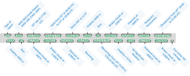
Of a TAF decoding :
TAF LBSF 161700Z 1618/1718 29012KT 5000 RA BKN015 OVC040 TEMPO 1618/1621 3000 RA SCT005 BKN015 OVC030 BECMG 1623/1701 9999 NSW SCT030 BKN060=
V. Change Groups and probability indicators: How to read forecast evolutions
V.1 BECMG
Let’s analyse the visibility forecast.
Suppose we are operating under VFR and planning to land on the 6th at 09:00 UTC, with a minimum visibility requirement of 5 km. The following forecast details are included in the TAF for our destination:
EXAMPLE
BECMG 0520/0523 VRB02KT 2000 BR BKN004 BECMG 0608/0611 26012KT 9999 NSW FEW015=
- Visibility will have deteriorated to 2000 m no later than 23:00Z on the 5th.
- An improvement is forecast, with a significant change expected between 08:00Z and 11:00Z.
This means visibility is expected to increase from 2000 m to more than 10 km. However, morning mist or fog can lift at different speeds depending on wind and sunlight conditions, so there is no guarantee that we will have the required 5 km of visibility by 09:00Z.
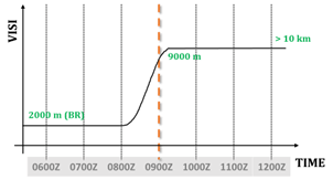
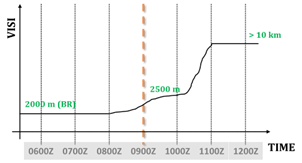
These diagrams show two examples:
in the first, visibility improves quickly; in the second, more slowly — but in both cases, the change occurs by the end of the period.
Therefore, in case of improvement, it is recommended to assume that conditions will improve only by the end of the change window.
Conversely, in case of deterioration, it is recommended to assume that the worsening conditions will begin at the start of the change window. This conservative approach ensures safer decision-making, especially when operating under VFR or near weather-related minima.
V.2 TEMPO
EXAMPLE
TEMPO 0520/0607 3000 BR BCFG BKN005
Between 20:00 UTC on the 5th and 07:00 UTC on the 6th, temporary conditions may include 3000 m visibility with mist and fog patches, and a broken cloud layer at 500 feet above ground level.
Those fog patches are expected to last less than one hour at a time and cover less than half of the 11-hour period.
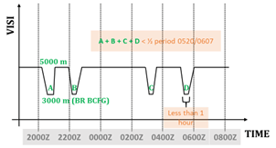
See our article on interpreting TAFs in the context of Commercial Air Transport (CAT).
V.3 PROB
How to interpret a probability:
- PROB30 = Low probability
- PROB40 = High probability
How you act on this depends on your environment — for example, whether you're flying in a valley with no escape options, or you have plenty of alternate aerodromes or diversion possibilities. It also depends on your experience level and how critical the flight is to you.
ICAO doesn’t define PROB30 or PROB40 as “low” or “high” officially — these are our operational interpretations. PROB40 still doesn’t guarantee the event will happen, but it does require greater caution.
It is better to be on the ground and regret not being in the air than to be in the air and regret not being on the ground.
See our article on interpreting TAFs in the context of Commercial Air Transport (CAT).
V.4 Appliying the Safe-Side Principle to Forecasts
BECMG :
Deterioration: Assume weather conditions worsen from the start of the BECMG period.
Improvement: Assume weather conditions improve only by the end of the BECMG period.
Always plan conservatively — never expect better conditions before they are fully established.
TEMPO / PROB30/40
Temporary improvements in weather conditions should generally be disregarded in flight planning.
Deteriorations depend on the weather type:
- Transient or showery conditions (e.g., thunderstorms, showers):
May be disregarded if you carry enough fuel to hold or divert upon arrival.
- Persistent conditions (e.g., haze, mist, fog, dust/sandstorms, continuous precipitation):
Should be taken into account as they are likely to impact flight operations.
For PROB30/40 combined with TEMPO:
This depends on your experience and risk mitigation capabilities. For example, in commercial aviation, the following recommendations apply:
- Deteriorations may be disregarded in flight planning.
- Improvements should be disregarded...
See our article on interpreting TAFs in the context of Commercial Air Transport (CAT).
VI. Other aviation reports
VI.1 ATIS/D-ATIS
ATIS = Automatic Terminal Information Service. The automatic provision of current, routine information to arriving and departing aircraft, available 24 hours a day or during a specified period.
Voice-ATIS = Voice Automatic Terminal Information Service. Provision of ATIS through continuous and repetitive voice broadcasts.
D-ATIS = Data Link Automatic Terminal Information Service. Provision of ATIS information via data link.
ATIS can be provided via radio frequency, data link, or telephone.
EXAMPLE
Radio Frequency

Telephone
Data link:
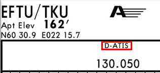
When available, D-ATIS (data link ATIS) information is indicated on Jeppesen taxi charts.
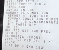
In METAR and SPECI, surface wind direction is reported in degrees true.
In ATIS, surface wind direction is reported in degrees magnetic.
VI.2 SPECI
SPECI = Special Weather Report. A special report issued when significant changes occur between routine METAR observations, providing immediate updates for safety.
VI.3 SIGMET
SIGMET = Significant Meteorological Information. It means information, issued by a meteorological watch office, concerning the occurrence or expected occurrence of specified en-route weather and other phenomena in the atmosphere which may affect the safety of aircraft operations and of the development of those phenomena in time and space;
VI.4 Common SIGMET Abbreviations
VI.4.1 Thunderstorms
OBSC = Obscured. Thunderstorms and cumulonimbus clouds obscured by haze, smoke or darkness.
EMBD = Embedded. Thunderstorms embedded within cloud layers not readily recognisable.
ISOL = Isolated. Individual features affecting less than 50% of the area concerned.
OCNL = Occasional. Features well separated affecting between 50% and 75% of the area concerned.
FRQ = Frequent. Little or no separation between adjacent thunderstorms affecting more than 75% of the area.
SQL = Squall Line. A line of thunderstorms with little or no space between clouds.
GR = Hail. Used to describe hail associated with a thunderstorm.
EXAMPLE
METAR LFOA 251700Z AUTO 13014KT 9999 ///CB 31/17 Q1009=
TAF AMD LFOA 251504Z 2515/2615 CNL=
LFFF SIGMET T02 VALID 251700/251830 LFPW-LFFF PARIS FIR/UIR EMBD TSGR OBS WI N4630 E00300 - N4715 E00200 -N4715 E00100 - N4745 E00100 - N4800 E00330 - N4630 E00415 - N4630E00300 TOP FL430 MOV N 25KT NC=
VI.4.2 Icing
ICE = Icing. Refers to severe and moderate icing in non-convective clouds.
FZRA = Freezing Rain. Severe icing caused by freezing rain.
VI.4.3 Turbulence
TURB = Turbulence. Refers to low level turbulence linked to strong surface winds, rotor streaming or CAT = clear air turbulence. Not used with convective clouds.
Moderate TURB. EDR peak value between 0.20 and 0.45.
Severe TURB. EDR peak value greater than or equal to 0.45.
EDR = Eddy Dissipation Rate. A quantitative measure of atmospheric turbulence intensity, representing the rate at which turbulent kinetic energy is dissipated by viscous forces in the atmosphere. It is used to classify turbulence severity, with higher values indicating stronger turbulence.
VI.4.4 Mountain Waves
MTW = Mountain Wave.
Moderate: Downdraft between 350 and 600 ft per minute (1.75 to 3.0 m/s) and/or moderate turbulence.
Severe: Downdraft greater than or equal to 600 ft per minute (3.0 m/s) and/or severe turbulence.
VI.5 AIRMET
AIRMET = Airmen’s Meteorological Information. Advisories for moderate weather phenomena of operational significance, typically intended for low-level flights.
VI.6 VOLMET
VOLMET = Meteorological information for aircraft in flight.
It is a service providing, by continuous and repetitive voice broadcasts, current METAR, SPECI, TAF and SIGMET information for selected aerodromes. VOLMET broadcasts are intended to keep flight crews informed about en-route weather conditions relevant to their flight planning and in-flight decision making.
VOLMET broadcast = The provision, as appropriate, of current METAR, SPECI, TAF, and SIGMET by means of continuous and repetitive voice broadcasts.
D-VOLMET = Data link-VOLMET. This is provision of METAR, SPECI, TAF, SIGMET, special air-reports not covered by SIGMET, and, where available, AIRMET via data link.
When prescribed by the competent authority, HF or VHF VOLMET broadcasts, or D-VOLMET services, or all of these, shall be provided using standard radiotelephony phraseologies.
EXAMPLE
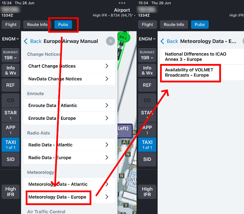
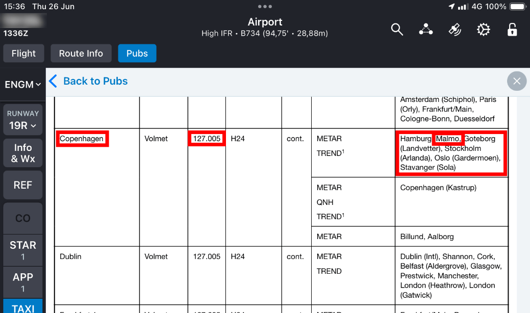
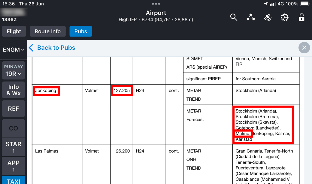
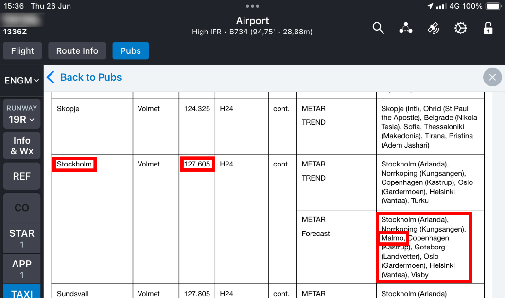
You can find the frequencies in each country’s AIP or on your preferred Jeppesen app:
You can get the weather for Malmö from stations broadcasting from Copenhagen, Jönköping, and Stockholm:
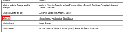
There are three frequencies to receive METAR and forecasts for Malmö, and these broadcasts are repeated in a loop. For example, on the Copenhagen frequency, if you hear the Oslo weather report, wait a bit longer before the Malmö information is broadcast. If you hear Hamburg weather, be ready to copy the next weather report concerning Malmö:
VI.7 GAMET
GAMET = General Aviation Meteorological Forecast. It provides concise forecasts of significant meteorological phenomena over specific flight information regions (FIRs) aimed primarily at general aviation pilots.
EXAMPLE
EBBU GAMET VALID 181800/190000 EBBR-EBBU BRUSSELS FIR BLW FL100SECN IHAZARDOUS WX NILSECN IIPSYS: 18. H 1026HPA CENTERED OVER U.K. STNR NC. ADVECTION OF DRY AND STABLE MARITIME AIR FM NNW.SFC WIND (30KT OR LESS): 18/21 N OF SAMBRE-MEUSE 360-030/04-07KT 18/21 COAST ? OFFSHORE 070-100/0508KT 18/21 S OF SAMBRE-MEUSE 330-360/06-09KT 21/24 020-050/04-06KT 21/24 COAST ? OFFSHORE 060-090/04-07KT 21/24 EXTREME SE 020/05-08KTWIND/T: 1000FT 010/10KT PS18 2000FT 360/15KT PS17 5000FT 350/10KT PS12 10000FT 310/15KT PS07SFC VIS (5KM OR MORE): +10KMCLD: NILFZLVL: ABV10000FT AMSLMNM QNH: 1022HPAOTLK: FM 00 TL 06 Z HAZARDOUS WX NIL=
VI.8 Local routine report and local special report
Local Routine Report = Meteorological report issued at fixed intervals for dissemination only at the originating aerodrome, providing detailed local observations.
Local Special Report = A meteorological report issued according to criteria established for special observations, intended only for dissemination at the aerodrome of origin where the observations were made.
VI.9 AIREP
AIREP = Special Air Report. Reports from aircraft in flight detailing encountered meteorological conditions, valuable for real-time data beyond ground observations.
VI.10 VAR
VAR : Volcanic Activity Report. Issued to report volcanic eruptions or ash clouds, providing critical safety information about volcanic hazards.
The report on pre-eruption volcanic activity, volcanic eruptions, and volcanic ash clouds shall be made in the format of a Volcanic Activity Report including the following meteorological information in the order indicated:
- Message type, VOLCANIC ACTIVITY REPORT;
- Station identifier, location indicator, or station name;
- Date and time of the message;
- Location and name of the volcano, if known;
A concise description of the event, including as appropriate the level of volcanic activity intensity, occurrence of an eruption with date and time, and the presence of volcanic ash clouds in the area with their direction of movement and height.
VI.11 NOTAM/ASHTAM/SNOWTAM
NOTAM = Notice to Airmen. A notice containing essential information about the establishment, condition, or change of any aeronautical facility, service, procedure, or hazard, which is timely and crucial for flight operations.
ASHTAM = Ash Temporary Airmen’s Information Message. It is a special series of NOTAM notifying by means of a specific format of a change in the activity of a volcano, a volcanic eruption and/or volcanic ash cloud that is of significance to aircraft operation
SNOWTAM = Snow Temporary Airmen’s Information Message. It is special series NOTAM given in a standard format, which provides a surface condition report notifying the presence or cessation of hazardous conditions due to snow, ice, slush, frost, standing water or water associated with snow, slush, ice, or frost on the movement area
VII. REFERENCES
- See the Commission Implementing Regulation (EU) 2017/373
- MET.TR.200
- AMC2 MET.TR.200
- AMC2 MET.TR.205(e)(1)
- MET.TR.205
- AMC1 MET.TR.205
- MET.TR.210
- AMC1 MET.TR.210
- MET.TR.220
- MET.TR.225
- AMC1 MET.TR.225
- MET.TR.250
- ATS.TR.325
- SERA.9010